So I keep Googling my own Post on Nabble, the MapGuide-Users forum where I describe how to roll out the ECW and MR SID Aerial Photo Support for MapGuide Open Source 3.1.1.
To save me, and anyone else time looking for it, I have posted the process here:
For MapGuide 3.1.1 in Windows 64 bit:
1. Download
http://download.gisinternals.com/sdk/downloads/release-1900-x64-gdal-2-2-mapserver-7-0.zip
2. Stop the MapGuide Service (using Control Panel > Administrator tools > Services)
3, Unzip and copy contents of the BIN folder from the ZIP into the
C:\Program Files\OSGeo\MapGuide\Server\Fdo folder
4. Copy the C:\Program Files\OSGeo\MapGuide\Server\Fdo\gdal\plugins folder
and paste it in the C:\Program Files\OSGeo\MapGuide\Server\bin folder.
5. Rename the plugins to gdalplugins so you end up with a folder called
C:\Program Files\OSGeo\MapGuide\Server\bin\gdalplugins
6. Start the MapGuide Service (using Control Panel > Administrator tools > Services)
This works for me every time.
If you are migrating from Autodesk Infrastructure Map Server, you will have to re-create your Raster Data Sources, but just rename them the same name as the original and your layers will point to the new GDAL ones.
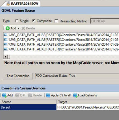
Example of new GDAL data source using multiple ECW files:

Hi..Gordon.
Tried this with Mapguide Open Sourc 3.1.1 to read ecw files but i didn’t get any result , in legend i found the layer is grayed , is there any solution for new release of MapGuideOpenSource-3.1.2.9484 to read raster source , Please suggest.
Thank you
Satish
These files work with 3.1.2
http://download.gisinternals.com/sdk/downloads/release-1900-x64-gdal-2-2-3-mapserver-7-0-7.zip
Gordon..
Thank you , with this i am able to see Tif images but i could not see Ecw format , please suggest the configuration to work with ecw. Thank you
Regards
Satish
Oh, also add the following to your system variables.
GADL_DATA – C:\Program Files\OSGeo\MapGuide\Server\Fdo\gdal-data
GDAL_DRIVER_PATH – C:\Program Files\OSGeo\MapGuide\Server\bin\gdalplugins
This works for 3.1.2 But everything SID comes through as greyscale when it is a color SID
I have that same problem.
I followed all the process steps.
4 channel ecw raster images appear in grayscale.
Try removing the 4th band of the ECW with something like FME.
For MapGuide 4 Preview 3 – I used the following:
https://download.gisinternals.com/sdk/downloads/release-1900-x64-gdal-2-4-3-mapserver-7-4-2.zip